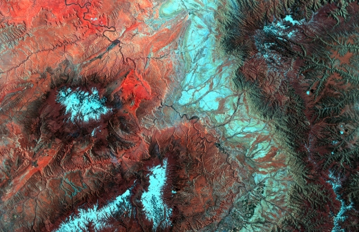
 During the last semester of my graduate degree program I was working on an advanced remote sensing project and I created an interesting false-color image. By running the signals of infrared and visible light through an algorithm I made this image to show where biological soil crusts are likely to be in arid environments (shown in red). The red and green layers consist of outputs from standard "brightness" and "greenness" algorithms that are included in most remote sensing software for vegetation analysis. Afterwards I edited the resulting image by rotating and enhancing the contrast for aesthetic purposes. This area is around the border between Colorado and Utah.
The purpose of the project was to test a remote sensing method for mapping microbiotic soil coverage in desert environments, specifically the Colorado Plateau, using a biological soil crust index (BSCI) developed by Chen et al in 2005. For more information on my report feel free to contact me directly.
0 Comments
|
Alex KeyScientist, photographer, and outdoor athlete based in Denver, Colorado. This blog is a place to share science-related news and ideas that I find interesting. 
Archives
June 2014
Categories
All
|
 RSS Feed